Autonomous farms
Your mapping is the first step toward farms operating with less and less human intervention.


Mapping Partner network
Available
With the Mapper and an antenna with corrected signal, AG4 certified partners map fields and become part of the AG4 autonomous farm ecosystem — with early access to what's new.
What sets it apart AG4 ecosystem
An AG4 Mapper partner isn't just buying equipment: they join the network that is building the autonomous farm, together with AG4.
Your mapping is the first step toward farms operating with less and less human intervention.
A profile unlocked in AG4 Atlas as a special customer, testing solutions before launch.
Offer your customers a field map ready for the machine's optimized route.
How it works Partner network
AG4 is building a network of partners who take AG4 Mapper to the field. The grower receives the mapped field, ready for route planning.
The partner receives AG4 Mapper and goes through AG4 certification.
With the antenna with corrected signal, they cover the area and record the boundary, obstacles and areas to avoid.
The survey goes to AG4 Atlas, which calculates the machine's optimized route.
AG4 Mapper network Brazil
Mapping is done by AG4 Mapper certified partners. To get service, talk to AG4: we learn about your area and refer you to the partner in your region.
Hover over or tap the points to see the city.
The first contact is always with AG4, which refers you to the nearest partner.
The kit AG4 Mapper
AG4 Mapper collects data in the field with your phone. Get it with the Nordian antenna and corrected signal already included, or use the compatible antenna you already have.
Compatible antennas
Product in the field
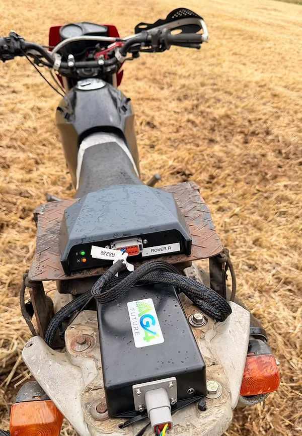
AG4 module and antenna with corrected signal, mounted on a light vehicle — such as a motorcycle — and monitored from your phone. The survey is done by driving around the area.
Records the points and the path of the survey.
Every point on the map comes from a corrected position, with the accuracy the machine needs to work.
The survey is monitored from your phone along the way.
Mapping workflow Step by step
The partner covers the area with the Mapper and the antenna with corrected signal. Each element of the field is recorded with its type, and at the end you get a file package ready for AG4 Atlas.
Choose the farm and the field. Each survey gets a number and is recorded with date and time.
The Mapper receives the position from the antenna with corrected signal and tracks signal quality throughout the route.
Field boundary, no-go area, obstacle, road, gate, refueling point or unloading point.
The Mapper records points at short distance intervals — in the sample survey, one point every 30 cm. For a pole, a single point with the safety radius is enough.
When you finish, the Mapper closes the outlines and generates the field files, along with the survey quality report.
The operational map goes to AG4 Atlas, which calculates the machine's optimized route.
If speed exceeds the recommended limit for keeping the spacing between points, the Mapper warns you — and the warning is recorded in the report.
Real example The generated map
Real survey of a field: boundary, a waterlogged area the machine must avoid and four poles recorded as obstacles, each with a safety radius.
What can be recorded
The generated file GeoJSON
At the end of the route, the Mapper creates a folder for the field with the elements separated by type, the complete operational map and the quality report. Maps are exported as GeoJSON, an open format that also opens in QGIS and other GIS software.
…__limite.geojsonField boundary…__proibido.geojsonAreas where the machine cannot operate, with the reason (e.g. water)…__obstaculos.geojsonObstacles, with type (e.g. pole) and safety radiusoperational_map.geojsonComplete operational map — this is what goes to AG4 AtlasFarm, field, survey number, equipment used, end date and time, distance covered and how many elements of each type were recorded.
A new survey of the same field creates a new dated folder. Previous versions are kept.
{
  "type": "Feature",
  "properties": {
    "feature_type": "OBSTACLE",
    "obstacle_type": "POLE",
    "safety_radius_m": 2,
    "position_method": "SNAPSHOT",
    "fix_type": "RTK_FIXED"
  },
  "geometry": { "type": "Point", "coordinates": [lon, lat] }
}
Each element carries its type and the data the route needs: here, a pole recorded as a single point, with a 2 m safety radius and fixed corrected signal.
Video
The boundary is recorded where the field really ends — at the border with the road.
Mapper → Atlas
The survey goes to AG4 Atlas, which uses the boundary and the recorded elements to calculate the machine's optimized route.
See AG4 AtlasFAQ
You become part of the AG4 autonomous farm ecosystem, with early access to what's new and a special customer profile in AG4 Atlas, testing solutions before everyone else.
AG4 certified partners, who use AG4 Mapper. If you need your area mapped, AG4 will refer you to a partner.
Fill out the “Become an AG4 partner” form on this page or message us on WhatsApp. AG4 will present the kit, the terms and the certification process.
Two options: with antenna (AG4 Mapper, Nordian antenna and corrected signal included for 1 year) or without antenna (AG4 Mapper to use with your compatible antenna). Both include an AG4 Atlas profile as a special customer and a place in the autonomous farm ecosystem.
Nordian, Trimble NAV-900, NovAtel and John Deere StarFire 6000.
Field boundary, no-go areas (with the reason, such as water), cleared areas, obstacles (with type and safety radius), roads, gates, refueling points and unloading points.
GeoJSON. Each survey generates a folder with the boundary, no-go areas and obstacles in separate files, the complete operational map, the survey identification (manifest.json) and the quality report (quality.json).
Yes. GeoJSON is an open format and opens in QGIS and other GIS software.
From the quality report: it shows how much of the route was done with fixed corrected signal, signal losses, the actual spacing between points, speed warnings and the final survey rating.
To AG4 Atlas, where it becomes the basis for the machine's optimized route.